

The French Way Map
03 June, 2026
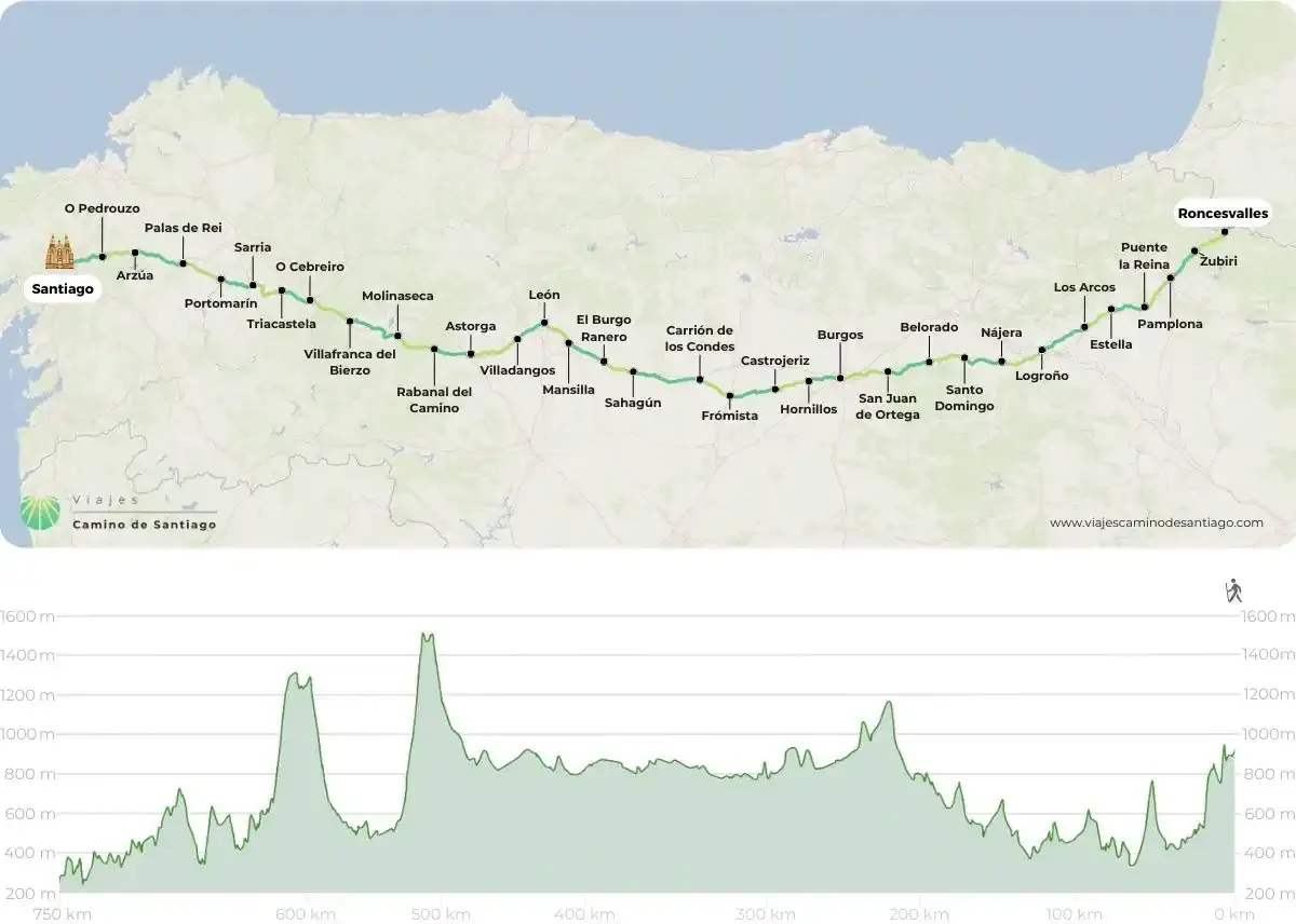
The map of the French Way at Viajes Camino de Santiago presents the classic route of the pilgrimage from Saint‑Jean‑Pied‑de‑Port to Santiago de Compostela, detailing the main stages, towns, crossings, and distances, as well as points of interest and services along the most well-known and traveled route of the Camino de Santiago.

The map you can see covers what is traditionally the complete route of the French Way from Roncesvalles, although it is true that you can start on the other side of the border with France by walking the 24 km that separate St Jean Pied de Port from this small Navarre town.
How can I interpret this map of the French Way?
This map breaks down the nearly 800 km of the French Way. Divided into 33 stages, it is a route that crosses a large part of the Spanish geography. Along the way, you will cross 4 Autonomous Communities and 7 Provinces. You will visit Navarre, La Rioja, Castilla y León (provinces of Burgos, Palencia, and León) and Galicia (provinces of Lugo and A Coruña)
On this adventure, you will encounter a total of 141 towns with services, so don’t be afraid! It is a Way with plenty of infrastructure, and on average, you will pass through a town with services every 5.6 km.
Important to consider!
Perhaps the sections where you should prepare the most to face the lack of services are those that separate the towns of Carrión de Los Condes -Terradillo de los Templarios (up to Calzadilla de la Cueza), Estella – Los Arcos (from Villamayor de Monjardin) and Belorado – San Juan de Ortega (from Villafranca Montes de Oca).
If you wish to start from St Jean Pied du Port, you should keep in mind that in the section from Orisson to Roncesvalles it will also be difficult to find services.
But… where do I start the Way?
The most common places to start this Way are: St Jean Pied de Port, beyond the border with France; Roncesvalles, in the heart of the Pyrenees; Logroño, in the heart of La Rioja; or Burgos. If you have limited time, it is common to start from Sarria, south of Lugo, from where you can meet the minimum requirement on foot. You can also start from O Cebreiro to cross Galicia from east to west, or if you prefer to enjoy entering this lush community, you can start from León.
Important! Keep in mind that if you are going to do it by bicycle, Ponferrada will be your starting point to meet the minimum requirement and be able to receive the Compostela.
Despite the absence of significant ascents on the French Way, you can see on the elevation map how the usual ups and downs from Roncesvalles result in a final accumulated elevation of around 3000 m. Don't worry, this route is undertaken by approximately 70% of pilgrims, so don't be concerned! You can do it!.
Without a doubt, if this is your first experience as a pilgrim on the Way of Santiago, keep this map handy because the French Way is your Way.
If you have already completed this route, we offer you the opportunity to embark on the Portuguese Way, a fantastic experience that will surely revive your adventurous spirit.