


Attention: Route not available for walking between November 1 and January 15
The small village of Roncesvalles is considered the first stop of the Jacobean route in Spanish territory and the starting point for thousands of pilgrims who set their course towards Compostela.
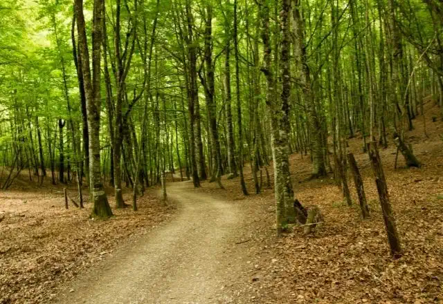
This Way will take you in the footsteps of millions of pilgrims who throughout history have contributed to the Jacobean route. Centuries of effort, adventure, and self-discovery at every step bathe the paths and trails through which, stage by stage, you will arrive in Santiago de Compostela.
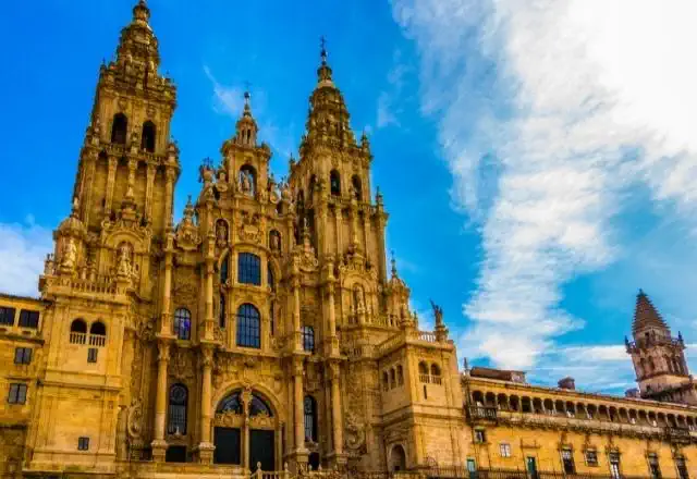
On your journey to what were once the ends of the Earth, you will traverse landscapes as diverse as they are spectacular, which will undoubtedly make this experience one of the most important of your life, as confirmed by the hundreds of thousands of pilgrims who arrive in the Galician capital each year.
Photos
Accommodations
- Most popular
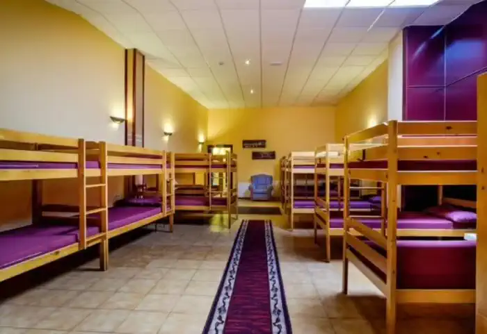
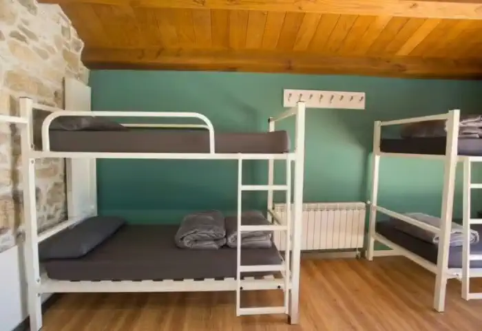
Basic accommodation (Private hostels)
1335 €
The most authentic accommodation on the Camino. Hostels are the ideal option for those traveling on a tight budget, solo pilgrims, or anyone who wants to experience the Camino de Santiago in its purest form. They are the perfect place to socialize, share stages, and connect with fellow walkers along this ancient route.
- Most popular
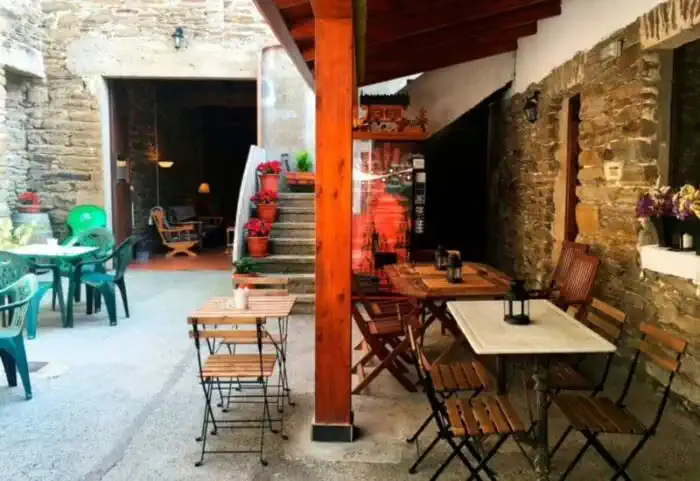
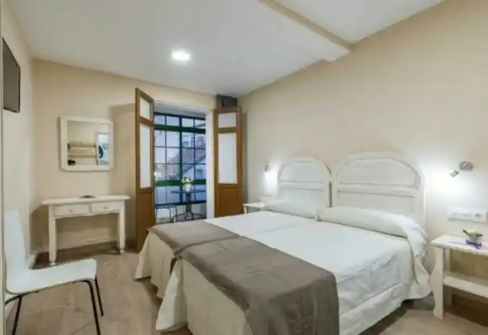
Private comfort (Guesthouses, rural houses and small hotels)
3039,50 €
The perfect balance between charm and comfort. Guesthouses, B&Bs and country houses await you in the villages along the Camino with private rooms, private bathrooms, TV, and daily cleaning service. Simple and welcoming, they are the ideal place to truly rest and enjoy the peaceful rural essence that only the Camino can offer.
Services
Included in all our routes
- Accommodation
34 days / 33 nights
- Complete documentation (Dossier and material for the Camino)
- Luggage transfer during the stages. (1 piece per person max 15 kgs)
- On-the-road emergency telephone assistance
- Pilgrim's Credential
- Travel insurance
Optional
- Supplement for single room
- Extra night in Santiago de Compostela
- Breakfast
- MP (Breakfast and dinner)
- Cancellation Insurance
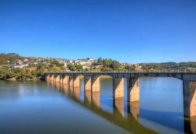
Map of the French Way from Roncesvalles to Santiago de Compostela
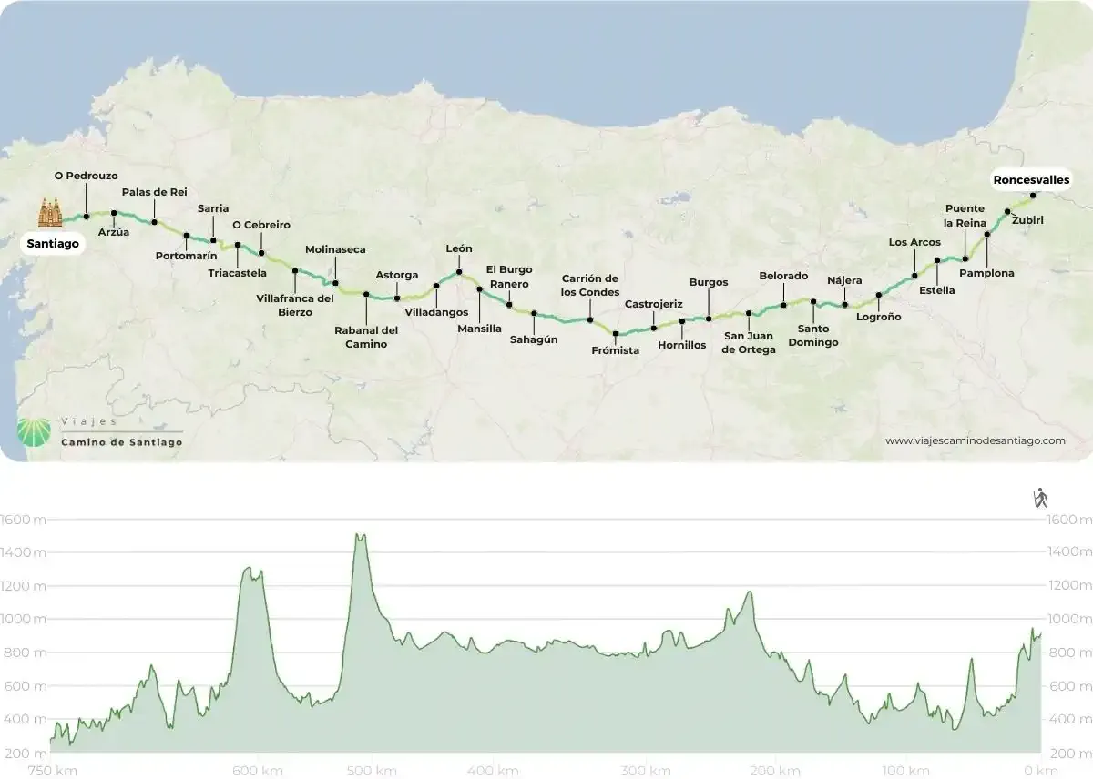
Stages
- day 1
Arrival at Roncesvalles
We start the stage crossing the Puerta de Santiago, in the upper part of the town. This is the traditional passage of the pilgrims who crossed this route to Roncesvalles, and was declared a World Heritage Site by Unesco in 1998. After this, we will cross the Rue d'Espagne, crossing the wonderful river Nive, an ancient place of trade of artisans. Once we leave the bridge, we will venture to start, really, the French Way, saying goodbye to the ancient 17th century Citadel on the hill of Mendiguren. This is where the adventure begins, and where the route forks into two variants:
- Official itinerary: Napoleon Route (25.7 km)
ATTENTION: From November 1 to March 31 the Napoleon Route is closed for safety reasons; it is therefore mandatory to go via Valcarlos. The fine for non-compliance can reach 12,000 euros.
We start our French Way from the medieval bridge over the Nive River and cross the centenary village of Saint Jean, surrounded by its ancient and beautiful wall. We follow the French signs Chemin de Saint Jacques de Compostelle along a rural road that passes through residential areas, such as Iruleya, Erreculus or Huntto, until we reach a spectacular viewpoint.
After leaving Orisson, where there is a bar-restaurant, the mountain road shows us the landscapes of the French Aquitaine. At kilometer 11.3 of the route we can see, if the fog does not prevent us, the Virgin of Biakorri, adorned with flowers, necklaces, crosses, shells and other pilgrim offerings.
After descending to Arnéguy we see next to the right shoulder a stone cairn with a carved wooden sign with the inscription Roncevaux/Orreaga. We leave the road and go through the mountain. We pass by the cross of Thibault and walk under the slopes of the Leizar Atheka peak towards the Bentarte pass, where we find the Fuente de Roldán. Already entering Navarra, the road continues to climb steeply up to 1430 meters to reach the pass of Lepoeder, the highest point of the stage.
From this point to reach Roncesvalles we have two well signposted options:
We can take the shorter option on the left and ride 3.6 km to Roncesvalles which, despite having steep slopes passes through the Don Simon forest. The option on the right goes through the Ibañeta pass, where the chapel of San Salvador is located and is only 400 meters longer.
- By-pass through Valcarlos (23.4 km)
With a more affordable challenge and slightly less ambitious views, we find the Variante through Valcarlos. This variant is the mandatory variant in winter due to snowfall, as well as the proximity to the national road. It is a safer route, especially under stormy and adverse conditions, or under the pilgrim's own physical condition.
We leave Saint Jean crossing the river Nive, following the signs until we reach the national road and the Route d'Arneguy. We continue on the road and take a paved track that crosses the river over a bridge. After 7 km of walking we arrive at Ventas de Arnéguy, on the border of Spain with France, where we can take advantage of its numerous stores, bars and restaurants to stop.
We cross the border and enter Spain. In front of Venta Peio we continue to the right on a dirt track that in just under a kilometer takes us to the center of Arnéguy. We cross again the river and the border to continue along a paved road, a beautiful stretch that climbs through lush forests until we reach Ondarolle, where we see Valcarlos from the viewpoint. We go down to the river and cross over a footbridge until we reach Valcarlos.
We leave Valcarlos by the N-135 road and descend to the small village of Gainekoleta. We continue along a path that returns to the national road and we alternate until we leave it on the left.
After an ascent, we reach the top of the Puerto de Ibañeta, where the legend places the Battle of Roncesvalles and, in his memory, a monolith was erected. We also find the modern chapel of San Salvador, whose bell served as a beacon for pilgrims disoriented by the fog.
After passing the Bird Migration Center, we descend through a beech forest, listening to the Otezul River in the background, until we reach Roncesvalles and put an end to our first stage.
To be taken into account
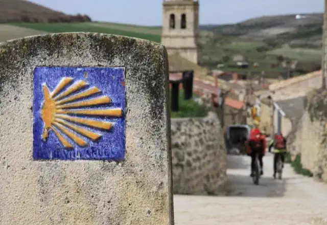
In France, the Camino is signposted with GR-65 markings in red and white, although there are also some yellow arrows.
If you are not used to long hikes in the high mountains, we recommend that you completely discard the stage along the Napoleon Route and opt for the variant of Valcarlos or start the Camino in Roncesvalles.
There is the possibility of dividing the stage into two sections. Overnight in the refuge of Orisson (essential to book in advance); from Saint Jean Pied de Port it is only a two-hour walk in great ascent with a difference in altitude of 628 meters, perfect to do in the afternoon and continue the route the next day.
The variant by Valcarlos has a positive difference in altitude of 885 meters, runs through the valley of Valcarlos, always near the national road, at a lower altitude than the main road by Honto. In case of snow or bad weather forecasts it is the most sensible option, although its attractiveness is somewhat lower.
Lugares de interés
- Ciudadela - Saint Jean Pied de Port
- Puerta de Saint Jacques - Saint Jean Pied de Port
- Iglesia de Notre Dame - Saint Jean Pied de Port
- Virgen de Biakorri - Ruta de Napoleón
- Fuente de Roldán - Ruta de Napoleón
- Iglesia de la Asunción - Arnéguy.
- Iglesia Santiago Apóstol - Valcarlos.
- Monumento al peregrino de Jorge Oteiza - Valcarlos.
- Puerto de Ibañeta
- Capilla de San Salvador
- Silo de Carlomagno - Roncesvalles
- Iglesia Colegiata de Nuestra Señora de Roncesvalles Roncesvalles
Typical dishes
- D.O. Ossau - Irati, Roncal or Idiazabal cheeses
- Stews in clay pots
- Trout stuffed with ham
- Chistorra
- Tortas Txantxigorri
- Pacharán, cider and wine
- day 2
Stage 1. Roncesvalles - Zubiri (21.4 km)
We bid a sad farewell to Roncesvalles along a path parallel to the N-135 in direction to Zubiri, which enters from the right into the Robledal de Brujas. A leafy forest where some of the most famous covens of the 16th century were held, which led to a notorious repression that ended up leading to the burning of nine people in the area. We will continue our route passing by the Cross of Roland, where the feats of Charlemagne are commemorated, until we reach the town of Burguete, where we will find bars where we can stock up on supplies.
We leave from
Burguete
and we cross the stream of the Urrobi river, going through a path between green meadows to Espinal, a small village surrounded by the landscape that Ernest Hemingway loved, who catalogued this stage as the most damned wildest territory of the Pyrenees. Just before the road leaves El Espinal, we turn off to the left and begin the ascent to the Mezkiritz pass, where we will enjoy spectacular views over the Erro valley.We descend until we reach Bizkarreta-Guerendiáin with half of the route behind us, it is a good time to stop to catch our breath.
We leave Bizkarreta along a path that runs to the left and reach the next village, Linzoáin. From here we begin to ascend to the Alto del Erro, combining steep slopes with stretches of ascent that make it difficult to reach the top. But the effort is rewarded with the majesty of the surroundings: forests of pine, birch and oak trees that give breath and strength to the pilgrim. After passing some electric towers, we will make a short stop to enjoy the incredible views offered by the viewpoint before starting the descent to Zubiri.
The descent gets harder and harder, so it is very important to take extreme precautions, especially in the rain. After the long descent of the Alto del Erro, we reach the Puente de la Rabia bridge over the river Arga, where we reach the end of the stage, Zubiri.To consider
Many pilgrims who start in Roncesvalles decide to finish their stage in Larrasoaña, 5.5 kilometres beyond Zubiri.
In Burguete the path runs along a road without a hard shoulder, so we must be extremely careful.
Although the climb is moderate, the ascent to the Alto del Erro is not difficult.Places of interest
- The White Cross or the Cross of Roldán
- Church of San Nicolás de Bari - Burguete
- Church of San Pedro - Gerendiain
- Medieval Stelae of the El Espinal Cemetery
- La Rabia Bridge - Zubiri
Typical dishes
- Pocha beans in Navarrese style with piperrada
- Veal from Navarre
- Roncal Cheese
- Trout
- Mushrooms and mushrooms (variety beltza mushroom)
- Shepherd's crumbs
- day 3
Stage 2. Zubiri - Pamplona (20.4 km)
We will say goodbye to Zubiri in the direction of Pamplona in the same way we arrived: crossing the iconic Puente de la Rabia. We arrive at the huge Magna factory, where the local magnesite deposit is extracted. It is a curious place, to say the least, that we will have to go around to get to Ilarratz, a small village where we can rest, refill our canteens. We follow the Camino and arrive at Larrasoaña, a village with an important Jacobean tradition. We continue the route crossing the Bridge of the Bandits, where in ancient times the pilgrims who dared to cross it were robbed.
We will continue to Akerreta, where we will find the church of the Transfiguration, which still preserves medieval elements such as the tower, the façade and the baptismal font.
We continue along a beautiful path that takes us to the bridge of Zuriain, where we can stop at the bar La Parada de Zuriain, take the detour to Ilurdotz and cross the river Arga again to go to Irotz. We leave the church of San Pedro behind us and continue on to the Iturgaiz bridge, of Romanesque origin, and continue along a path that runs parallel to the national road. When we reach some farmhouses we have two options: To go up to the village of Zabaldika or to go along the left side of a cultivated field.
We continue on our way and we are presented with a new dilemma with two itineraries. On the one hand, we can follow the comfortable river walk, which will take us to Huarte, a village that is now part of the outskirts of Pamplona, or follow the path of the original Pilgrims' Route to Santiago de Compostela, which continues from the same recreation area. Both variants come together a couple of kilometres further on.
We cross the national road through a tunnel and find the turn-off to Huarte. We continue in the same direction and go down to Trinidad de Arre, one of the most spectacular points of the stage and where the Camino de Baztan meets. It is worthwhile to take a break in the village and visit the Basilica of the Trinity and the church of San Roman.
We return to the road passing through the main street of Villava, famous all over the world for being the birthplace of the cyclist Miguel Induráin. We are now at the gates of Pamplona. Almost without transition we reach Burlada, cross the Magdalena Bridge over the Arga River, go around part of the wall and enter the old part of Pamplona, putting an end to our stage.
To consider
If we plan to arrive in Pamplona between the 6th and 14th of July we must be proactive or book in advance, as the accommodations are usually full and prices increase exorbitantly. We can also choose to extend the stage to Cizur Menor, which would mean walking about 5 kilometres more.
Places of interest
- Church of San Nicolás de Bari - Larrasoaña
- Bridge of the Bandits - Larrasoaña
- Bridge of Irotz
- Ultzama Bridge
- Hermitage of La Trinidad de Arre
- Cathedral of Santa María la Real - Pamplona
- Town Hall - Pamplona
- Navarre Palace - Pamplona
- Plaza del Castill - Pamplona
Typical dishes
- Tudela artichokes with clams
- Piperrada and gazpacho from Navarre
- Asparagus and piquillo peppers
- Roncal and Idiazábal D.O. Cheeses
- Beef T-bone steak/beef brisket
- Chilindron lamb
- Salmon from Bidasoa, kokotxas, hake Navarrese style
- Roscos blessed by San Blas
- Pacharán
- day 4
Stage 3. Pamplona - Puente la Reina (23.9 km)
We start the stage from the Town Hall Square and say goodbye to Pamplona and head towards Puente la Reina, crossing the medieval bridge of Azella, which crosses the river Sadar. The road takes us to Cizur Menor. After a crossroads, we see a detour to Guenduláin, an abandoned hamlet where only the ruins of a church and a mansion remain.
We continue in a slight ascent until we reach Zariquiegui, where we can stock up on supplies and visit the Church of San Andrés. Here begins the dreaded rise of the Alto del Perdón, we pass by the Fuente de la Reniega, where, according to legend, the devil used to tempt pilgrims with water in exchange for renouncing their faith.
With patience and strong winds, we finally reached the top of the Alto del Perdón, one of the most famous and photographed points of the Camino de Santiago, both for the spectacular views and for the unique sculptures representing a family of pilgrims from the Middle Ages.
In an inscription we can read: "Where the path of the wind crosses the path of the stars. After a well-deserved stop, the descent to Uterga begins. The descent is quite steep in the first stretch and the track is uneven, so it is advisable to take extreme caution.
We pass Uterga, a pretty village at the foot of the mountain, and without difficulty we reach Muruzábal. In the middle of the village we find the detour to the wonderful Romanesque chapel of Santa María de Eunate, which is worth a visit at the cost of lengthening the stage by 3.2 km.
If we do not take the shortcut we will arrive at Óbanos, where the Mystery of Obanos is commemorated annually, which is a Festivity of National Tourist Interest. We continue the last stretch along the path of the river Robo, which will take us to Puente de la Reina.
To consider
In the Alto del Perdón the wind usually blows hard, so we recommend to do the stage with warm clothes even in summer. The detour to the hermitage of Santa María de Eunate is perfectly signposted. It is an octagonal Romanesque church of great beauty which, we insist, is well worth a visit.
You won't have any supply problems during the stage, as you will find a lot of bars where you can make your stops. Even in the Alto del Perdón there is usually a mobile bar from Easter to October.
Places of interest
- Church of San Miguel - Cizur Menor
- Church of San Andrés of Zariquiegui
- Muruzábal Palace
- Church of San Esteban de Muruzábal
- Hermitage of Santa María de Eunate
- Church of the Crucifix - Puente la Reina
- Church of Santiago - Puente de la Reina
- Plaza Mayor and Casa de los Cubiertos - Puente de la Reina (Bridge of the Queen)
Typical dishes
- Wines of Señorío de Sarria
- Ribs to the Sarmiento
- Campollano Beans
- Cheeses of Urbasa
- Lean meats with tomato
- Trout with ham
- Cod in ajoarriero sauce
- day 5
Stage 4. Puente la Reina - Estella (21.6 km)
We start the stage from Puente la Reina to Estella, crossing the river Arga and ascend to the village of Mañeru, where many battles of the Carlist Wars were fought in the past. We can take the opportunity to visit the church of San Pedro. We continue for several kilometres, accompanied by vineyards and olive groves, on a quiet and pleasant walk to the village of Cirauqui, which is characterised by its wall, which we must cross.
We leave Cirauqui following an old Roman road, cross the Roman bridge and follow the signs and cross the motorway until we reach the Canal de Alloz, near the Salado river.
The story goes that this river brought death, as it was said that its water was poisoned, and that the locals urged the pilgrims to drink from it, and thus steal their belongings.
We cross the dual carriageway again by an underpass, and then we go uphill to Lorca, a town closely linked to the Camino since the 13th century, where we will find the church of San Salvador. On the outskirts of Lorca the road coincides with a path that leads to the cross of Maurien, which dominates the landscape from the heights. Between rural paths, fields and hills we arrive at Villatuerta.
We leave Villatuerta on the last stretch of the stage that runs along the plain to the hermitage of San Miguel, where many pilgrims leave their wishes and thoughts. We descend to a picnic area, where a stone cairn crowned by a virgin reminds us of a deceased Canadian pilgrim. We cross the road through a tunnel and reach a bridge over the river Ega. We enter Estella through Curtidores Street and we finish the day enjoying the charms of this beautiful Jacobean town known as "Toledo of the North".
To consider
The stage does not present great difficulties, except for a short slope in which we climb 135 meters in approximately 1 km. In addition, along the route you will find a large number of bars and restaurants where you can have a drink and refresh yourself.
Places of interest
- San Pedro Church - Mañeru
- Church of San Román - Cirauqui
- Church of the Assumption of Villatuerta
- Church of San Pedro de la Rúa - Estella
- Palace of the Kings of Navarre - Estella
- Church of the Holy Sepulchre - Estella
- Urban wall - Estella
Typical dishes
- Rocks of the Puy
- Idiazabal D.O. Cheeses
- Dishes such as trout Navarrese style
- Red beans with bacon or oxtail
- Piquillo peppers
- day 6
Stage 5. Estella - Los Arcos (21.3 km)
Once we have left Estella behind , we head towards Los Arcos, crossing the river Ega, leaving behind the Palace of the Kings of Navarre and the Church of San Pedro. We will advance until we reach the manor of Ayegui, where we can find the curious forge of Ayegui, where the craftsman Jesús Angel Alcoz reproduces in the hot iron the typical shapes of the Way of St. James.
We leave Estella leaving behind the Palace of the Kings of Navarre and the church of San Pedro. We follow the signs and, almost without noticing, we arrive at Ayegui, as it is practically absorbed by Estella. In the San Pelayo square, a signpost invites us to turn left and go up to the Irache Monastery.
We arrive at one of the great landmarks of the whole Camino, the famous Bodegas Irache and its Wine Fountain where, under a carving of Santiago, two taps are born, one for water and the other for wine.
After refreshing ourselves as tradition dictates, we continue to the Irache Monastery, a mixture of Gothic, Renaissance and Baroque whose cloister can be visited. We leave Irache along dirt and gravel paths, until we reach a crossroads where we see two alternatives: on the one hand, we find a slightly shorter one that crosses the slopes of Montejurra through a wooded area to Luquin, and the second, which is the original route, passes through Azqueta and Villamayor de Monjardín. We continue along the traditional path, through Azqueta, which takes us through a housing estate and a tunnel until we enter a wooded path.
We arrive at Azqueta, a town that welcomes pilgrims with a nice graffiti. Here we will meet one of the most endearing people of the whole Camino. Known as Pablito el de las Varas or "the man who has become famous for giving sticks", as he is called in the village. Pablito has been giving walking sticks to pilgrims for 25 years and explaining to them how to use them correctly. It has its intricacies!
Equipped with a good stick, a masterly lesson and a very pleasant time with our friend, we continue to Villamayor de Monjardín. Shortly before arriving we find the Fuente de los Moros (Fountain of the Moors), which used to quench the thirst of medieval pilgrims. Once in the village, we must visit the church of San Andrés, with its silver processional cross and its capitals. At the top of the village we can see the remains of the castle of San Esteban de Deyo, declared of National Historic Interest. Its bell is still working, and they say that if you ring it, its tolling can be heard all over the region.
We continue through monotonous farm fields for several kilometers. If we are lucky, and we are in high season, we will find La Flecha Amarilla. A mobile bar that serves from cold drinks to mixed dishes for pilgrims passing by. And we enter the final stretch to Los Arcos, where we can rest from a day full of emotions of the Camino, as well as enjoy the heritage of the Church of Santa Maria de Los Arcos, one of the most important in Navarre.
To consider
This stretch of the French Way between Estella and Los Arcos is quite long and monotonous. It is important to stock up with plenty of water as there are no services. Also, if you do the Camino in the hottest months of the year, it is advisable not to start walking without a hat or cap and sunscreen.
Places of interest
- Forge of Ayegui
- Wine Fountain
- Irache Monastery
- Castle of San Esteban de Deyo - Villamayor de Monjardín
- Church of Santa María de Los Arcos - Los Arcos
- Portal de Castilla - Los Arcos
Typical dishes
- Variety of wines from the Irache wineries
- Sausages from Navarre
- Cheeses D.O.
- Hake a la koskera
- Pollack ranch
- Fried milk
- day 7
Stage 6. Los Arcos - Logroño (27.6 km)
We will start our stage towards the capital of La Rioja leaving behind the chapel of San Lázaro. The first village we will find after leaving Los Arcos on our way to Logroño will be Sansol, where we will find a pharmacy, a hostel and a bar. We leave the village crossing the road and descend to a solitary house located in the middle of a bend. An arrow guides us to the left down a cobbled chute. We go through a tunnel, over a bridge and find a fountain that offers us water at the gates of Torres del Río.
Torres del Río is a small town famous for the church of the Holy Sepulchre (12th century) which has a tower attached to it that may have been used as a lighthouse to guide pilgrims in the Middle Ages.
After the stop, we continue to Viana on a steep and uncomfortable climb with a road surface that varies between asphalt, flagstones, gravel and dirt. We cross the road with caution several times until we reach the hermitage of the Virgen del Poyo. We go down again to the road that takes us to Bargota, where it is said that a sorcerer who was condemned by the Inquisition was given shelter. We continue straight on and descend to the Cornava ravine, with a steep slope of more than 125 metres, where we must take extreme precautions.
We continue along a path of pines and fruit trees, at the bottom of the ravine we see some plots of vineyards and olive trees. We continue between slides until we reach Viana, where we can visit the fabulous Gothic church of Santa Maria, which has an original Renaissance façade.
The stretch from Viana to Logroño is a walk for our already tired legs, although with more asphalt than we would like, forcing us to cross the road several times and extreme caution.
As a curiosity, in this section we will find the stall of another of these endearing characters of the Camino, Mrs. Felisa. Felisa was a hospitalera who lived her life on the edge of the Camino de Santiago, welcoming pilgrims from all over, offering them water and a snack (usually figs from her own fig tree). After Felisa's death in 2002, her affectionate character and her willingness to help others remained so strong in her family that one of her daughters, Mari, has been doing this work for some time.
After the last road crossing, a comfortable path leads us to the entrance of Logroño, which we enter through a park. We cross the Ebro by the bridge of San Juan de Ortega and we put an end to our stage enjoying the attractions of this emblematic historical capital.
To consider
The stage between Los Arcos and Logroño runs between quite a few gravel roads that can be a bit desperate if you don't step firmly on it.
Places of interest
- Church of the Holy Sepulchre - Torres del Río
- Hermitage of the Virgin of Poyo - Bargota
- Viana Town Hall
- Church of San Bartolomé - Logroño
- Co-cathedral of La Redonda - Logroño
Typical dishes
- Wines D.O. La Rioja
- Potatoes and eggs Rioja style
- Lamb chops
- White tuna with tomato Rioja style
- Tapeo in the streets Laurel and San Juan in Logroño
- day 8
Stage 7. Logroño - Nájera (29 km)
Crossing the square of Santiago, we say goodbye to Logroño to get back on the Camino in the direction of Nájera. We pass under the Puerta del Camino and walk for quite a while until we reach the Parque de San Miguel and enter the Parque de la Grajera, at the foot of the reservoir. This magnificent spot is home to numerous animal species, from friendly squirrels to majestic swans, which will delight the most curious.
We walk uphill along dirt tracks and crop fields to reach the Alto de la Grajera, which will lead us to the road to Navarrete, but not before we see the emblematic Osborne bull.
Once in Navarrete we can enjoy the town that once served as a border with the Kingdom of Navarre, where the Castilian kings of the twelfth century defended their territory. After visiting the Renaissance church of La Asunción, we cross the old town to return to the Camino.
We leave Navarrete behind and head towards Ventosa, where the church of San Saturnino stands out. Next to the wineries a stony path leads us to the Alto de San Antón, with an easy and short ascent. From the top we can contemplate the valley of the Najerilla and the town of Nájera, apparently close but really distant.
We go down to the crossroads of the N-120 road and continue to the Poyo de Roldán, where the legendary combat between Roldán and the giant Ferragut took place.
Beyond this point, we will continue along a path that leads to a bridge over the Yalde River, where, after a kilometre and a half, we will reach the Poema del Camino Park, where we can take a break along the way. We continue along the same path until we reach the river Najerilla, which will welcome us to the historic town of Nájera.
To consider
The stage can be shortened by spending the night in the small village of Ventosa; on the other hand, we can save 600 metres without passing through this village by taking a shortcut that is well signposted.
Places of interest
- Remains of the church of San Juan de Acre - Navarrete
- Church of San Saturnino - Ventosa
- Monastery of Santa María la Real - Nájera
- Najerillense Historical Museum - Nájera
- Convent of Santa Elena - Nájera
Typical dishes
- Pocha beans with quail eggs
- Broths
- Artichokes sautéed with ham
- Suckling pig
- Grilled lamb chops
- Homemade spicy chorizo
- Snails Rioja style
- Stuffed peppers
- day 9
Stage 8. Nájera - Santo Domingo de la Calzada (20.7 km)
The stage begins bordering Santa María la Real, which houses the Cloister of the Knights, where the nobles were buried since the 16th century. We leave Nájera behind in the direction of Santo Domingo de la Calzada, and after crossing the Valdecañas stream we reach Azofra via an asphalted road, where we should stock up on supplies as we will not find any more services for another ten kilometres. This town of Arab origin had a pilgrims' hospital until the 19th century, and still has the Church of Nuestra Señora de los Ángeles, where we find a carving of the Apostle Santiago.
Detour to San Millán de la Cogolla: 15 km off the Camino we will find San Millán de la Cogolla, with its famous monasteries of Suso and Yuso, cradle of the Castilian language and declared World Heritage Site.
Those interested in visiting them should take the detour at the exit of Azofra, the road towards Alesanco, Cañas and continue to San Millán. To return we can follow the road from Villar de Torres to Cirueña, where we will find the yellow arrows.
We continue our route and reach the Cerro de los Templarios. As if it were a dream, we begin to leave behind the vines of La Rioja, and we enter the vast seas of cereals of Castile. A long and eternal stretch without refreshment points, where the heat and the absence of shade will become our worst enemy. We will arrive at a newly built residential area surrounded by a golf course. After this walk through the farmland of the Castilian plateau, and after having walked quite a few kilometres from Nájera, we will be able to see for the first time the cathedral of Santo Domingo de la Calzada, where we will enter through an area that is more asphalted than we would like.
We crown our stage arriving at Santo Domingo de la Calzada, but we cannot say goodbye without visiting its co-cathedral of different architectural styles. Legend has it that a pilgrim who was travelling with his parents was unjustly executed, so Santo Domingo himself granted him life after the gallows. When the news reached the local magistrate, who was eating some roast fowl, he said, incredulously to his parents, "Your son is as much alive as this cock and hen which I was about to eat before you troubled me." Then the birds were resurrected, regaining their feathers and their flesh, and began to fly and sing around the table, thus giving rise to the saying.
To consider
On this day we will face long stretches without being able to protect ourselves from the sun, so it is advisable to wear a hat or cap and apply sunscreen, especially in the summer months.
Places of interest
- Church of Our Lady of the Angels - Azofra
- Monasteries of Suso and Yuso - San Millán de la Cogolla
- Cathedral - Santo Domingo de la Calzada
- Paseo del Espolón - Santo Domingo de la Calzada
Typical dishes
- Potatoes Rioja style
- Chickpeas with meat and vegetables
- Ahorcaditos (small puff pastries filled with almond cream)
- day 10
Stage 9. Santo Domingo de la Calzada - Belorado (22 km)
We leave Santo Domingo de la Calzada early in the morning towards Belorado. We leave the village through the old quarter, crossing the bridge over the river Oja. Here we will find the hermitage of the Bridge, from 1917, rebuilt here since the flow of the river swept away the old hermitage. We continue on to reach the road, which we will have to cross to continue for several kilometres parallel to the N-120, which will take us to the town of Grañón, the last village in La Rioja. We are welcomed by the Cross of the Brave, which recalls the conflict between the inhabitants of Grañón and Santo Domingo.
On leaving Grañón, we walk again between fields of land consolidation that furrow the cereal, relieved of the monotony by rows of poplars that grow on the banks of rivers and streams.
Two kilometres further on, an information panel welcomes us to Castilla y León, the community that will accompany us for two weeks.
From the panel we can already see Redecilla del Camino, the first Castilian village we reach after overcoming a long straight road. In the church of Redecilla we will find one of the most elaborate baptismal fonts of all the Way of St. James. We continue parallel to the N-120 until we cross the river Relachigo, to later reach the municipality of Castildelgado, with a fountain where we can refresh ourselves.
We go 2 km further until we find Viloria de Rioja, birthplace of Santo Domingo, where the Brazilian writer Paulo Coelho sponsored a small hotel. We will continue a few more kilometres until we reach Villamayor del Río, which is said to be a village of the three lies, as it is neither a town, nor is it a major town, nor does it have a river. We will continue for about 5 km until we reach Belorado, putting an end to our hike.
To consider
In all the villages, except in Viloria, we will find bars and restaurants where we can make stops. There are several sections of the Camino that cross the road, so we must be extremely cautious and watch out for traffic.
Places of interest
- Grañón Bakery - Grañón
- Church of San Juan Bautista - Grañón
- Hermitage of Nuestra Señora de la Calle - Redecilla del Camino
- Church of the Assumption - Viloria de Rioja
- Remains of the Castle - Belorado
Typical dishes
- Products from the Beliforian garden (onions, garlic, peppers...)
- Caparron
- Black pudding from Belorado
- Suckling lamb
- day 11
Stage 10. Belorado - San Juan de Ortega (23.9 km)
We will start the stage leaving Belorado in the direction of San Juan de Ortega through the main gate until we reach a road that will take us to Tosantos, the first village of this stage. Here we find the hermitage of Virgen de la Piedra, built inside the mountain. We follow the road to the village of Villambistia.
Not even two kilometres will pass until we reach Espinosa del Camino. We continue ascending a small hill and on the way down we see the apse of the Mozarabic monastery of San Félix, where some chronicles place the tomb of Diego Porcelos, founder of Burgos.
We continue parallel to the road and crossing the river Oca before reaching Villafranca. From here the itinerary changes its profile completely. We have ahead of us a wonderful three-hour ride through the Montes de Oca, so feared in the Middle Ages for the presence of evildoers.
We start from Villafranca, on the right of the church in a climb without contemplations. We pass the Mojapán Fountain, where there is a rest area and soon we see a monument to those shot in the Civil War. We cross the ravine of the river Catarrón and continue the ascent to the Alto de la Pedraja (1,157 m), the highest point. We ride along a wide track through an oak forest and, after a long descent, we arrive at the end of the stage, San Juan de Ortega.
To consider
We have the option of extending this stage by staying overnight in Agés or Atapuerca, a perfect option if we want to spend the next day in Burgos.
There are bars and restaurants in all the towns along the stage, although with a limited offer. In Villafranca Montes de Oca you will find all the services.Places of interest
- Hermitage of Nuestra Señora de la Peña - Tosantos
- Church of Santiago Apóstol - Villafranca Montes de Oca
- Monastery - San Juan de Ortega
- Atapuerca
- Romanesque Church of San Miguel - Agés
- Parish Church of Agés
Typical dishes
- Suckling lamb
- Burgos black pudding
- Fresh cheese from Burgos
- Honey from Merindades
- Yolks
- Fried Bones
- day 12
Stage 11. San Juan de Ortega - Burgos (25.8 km)
We leave San Juan de Ortega in the direction of Burgos along a dirt track through a pine forest and arrive at Agés. From here we continue by road to Atapuerca, where we can visit the interesting archaeological site.
We begin the ascent to the Sierra de Atapuerca along a stony track. At the top we can already see Burgos in the background. We go down to Villabal and we get to a local road, practically without traffic.
Just at the exit of the village we turn left to take a track and start the ascent by the Atapuerca Mountains. We will continue the ascent to the Alto de Atapuerca, not very steep, but not very firm, so, with care, we will ascend until we reach the Cruz de Madera, from where we can see the city of Burgos. It was on the plain that we can see from here that the battle of Atapuerca was fought, which would govern the distribution of the Spanish kingdoms in the 11th century.
From here we will begin to descend through a complicated area until we reach Cardeñuela Riopico, right next to the river, where we will find a place to rest. We continue towards Burgos, passing through Orbajena Riopico, to reach the crossroads that will decide our entry into the Castilian city.
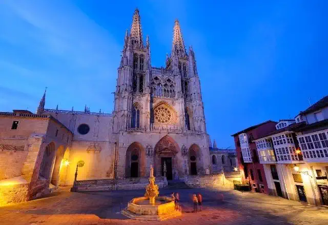
Here you can decide whether to take a shorter route, but through a completely urban and industrial area, or take the longer route that will take us around the airport, but we will enter Burgos through a beautiful park. And now we are in Burgos, where we will find the Cathedral of Santa María de Burgos, one of the most imposing in the country, as well as the home of the tomb of Rodrigo Díaz de Vivar, the Cid Campeador.
To consider
If on our way from San Juan de Ortega to Burgos we take the variant of Castañares We must cross a pedestrian crossing of the national road N-120, take Óbidus street until the end, skirt a big factory on the right, and cross the Arlanzón river by a pedestrian bridge; from there, and until the Old Town of Burgos itself, we follow a pedestrian walk along the Arlanzón river.
Pilgrims wishing to visit the Atapuerca Archaeological Site should make their reservation in advance at http://www.atapuerca.org/.
Places of interest
- Atapuerca Archaeological Site
- Burgos Cathedral - Burgos
- Church of San Nicolás - Burgos
- The Castle and its Viewpoint - Burgos
Typical dishes
- Suckling lamb
- Grilled cutlets
- "Rotten pot"
- Burgos black pudding
- Burgos Cheese
- Castilian soup
- Crayfish
- day 13
Stage 12. Burgos - Hornillos del Camino (21 km)
If we do our Camino in summer it is very important to leave Burgos early to avoid the sunny roads without shade before arriving at Hornillos del Camino. We leave the city from the Cathedral until we reach the bridge of Malatos, leaving the Monastery of Las Huelgas and the Hospital del Rey on our left. We leave the road on the right and take a path that leads us to Villalbilla.
We cross the railway tracks and continue until we cross the river again over the Archbishop's Bridge and enter Tardajos, which welcomes us with an elegant 18th century transept. We leave the road and take a country road that crosses the small valley of the river Urbel. Formerly it was a complicated access due to the floods of the river that devastated the land. Hence the well-known saying: "From Rabé to Tardajos, you will not lack for work; from Tardajos to Rabé Free us, Dómine!" We arrive at Rabé de las Calzadas. The Camino continues for nine kilometres along rural roads between cereal fields.
We reach the highest point of the stage and descend along the Cuesta de Matamulos to the valley of the river Hormazuelas.
Already in Hornillos, we will be able to see a village street crowned at the end by a parish church, after which we will be able to observe a beautiful sunset over the golden fields of cereal.
To consider
We can stick to the Burgos - Hornillos del Camino stage or extend it and do 31 km to Hontanas, which has several hostels. Or go to San Bol, which has a lonely hostel in the middle of the vastness. It is not an easy stage for the cyclists, who will have to get off the bike in some sections and cover them on foot.
In the summer months it is essential to carry a water bottle full of water, sunscreen and sun visors or hats to protect you from the scorching sun. In winter, on the other hand, we will need good warm clothes to resist the frost.
Places of interest
- Hermitage of the Virgin of the Monastery - Rabé de las Calzadas
- Palace of the Count of Villariezo - Rabé de las Calzadas
- Parish Church of San Román Mártir - Hornillos del Camino
Typical dishes
- Burgos black pudding
- Fresh cheese from Burgos
- Suckling lamb
- day 14
Stage 13. Hornillos del Camino - Castrojeriz (19.9 km)
We leave the village of Hornillos del Camino and head towards Castrojeriz between the endless paths of the cereal fields, practically without seeing the shadow of a tree for several kilometres. We find a small detour that will take us, if we opt for it, to San Bol, a small and secluded place that lives by and for the Camino. We continue for several kilometres to the town of Hontanas, where we can make the first tactical stop of the day.
After a long stretch of flat land we find the Monastery of San Antón, converted into a private hostel, but which was once the Palace of King Pedro I of Castile, and which was ceded to the Order of the Antonians. In the arches of the old church the parishioners performed the cure of the fire of San Antón, a very widespread food disease in the Middle Ages.
And without further ado, we arrive at Castrojeriz where we will find the churches of San Esteban and San Juan. If we still have strength left we can visit the Castle of Castrojeriz, where it is said that Queen Leonor of Castile was assassinated by order of Pedro I. A highly recommended visit to enjoy its views, which will make the cereal fields look, at sunset, like a huge golden sea.
To consider
As in the previous stage, it is important to go out with plenty of water and sun protection, and to avoid walking during the hottest hours of the day.
Places of interest
- Hontanas - Church of the Immaculate Conception
- Church of the Virgen del Manzano - Castrojeriz
- Church of San Juan - Castrojeriz
- Main Square and Town Hall - Castrojeriz
- Hospital General San Antón - Castrojeriz
- Castle of Castrojeriz - Castrojeriz
Typical dishes
- Aged sheep's milk cheese
- Suckling lamb and pigeons
- Stick threads
- Esparceta (alcoholic beverage made from wine and other ingredients)
- day 15
Stage 14. Castrojeriz - Frómista (24.7 km)
We leave Castrojeriz towards Frómista and face the first challenge of the stage. We cross a wooden bridge that takes us to the Alto de Mostelares. After a steep slope we admire the flat landscape of the Castilian plateau and descend along a tarmac road.
The path gradually becomes flat and leads us to the Piojo fountain, a perfect spring to quench our thirst. We will continue through the parish of San Nicolás to reach the Fitero bridge, over the Pisuerga, the old border between Castile and Aragón.
We cross the river and arrive at Itero de la Vega, where we should stock up to complete the remaining 8 km to finish the stage. We leave behind the hermitage of Nuestra Señora de la PIedad and the Church of San Pedro, cross a road and head towards Boadilla del Camino. This route does not have any shade. We continue leaving behind the church of the Asunción to go directly to Frómista, parallel to the Canal de Castilla, which will give us the entrance to the end of this stage.
To consider
As in previous stages, exposure to the sun is almost total.
Places of interest
- Fitero Bridge - Hermitage of San Nicolás
- Itero de la Vega - Ermita de la Piedad (Chapel of La Piedad)
- Itero de la Vega - Church of San Pedro
- Boadilla del Camino - Church of Nuestra Señora de la Asunción
- Frómista - Church of San Martín
- Frómista - Church of San Pedro
- Bodegas Zarzavilla (guided tour available)
Typical dishes
- Pigeon
- Vegetable stew
- Suckling lamb
- Sausages and sausages from Palencia
- Country biscuits
- Sequillos
- day 16
Stage 15. Frómista - Carrión de los Condes (18.8 km)
We start the stage following the course of the P-980 road, which joins Frómista and Carrión de los Condes in a straight line. After passing a couple of roundabouts we arrive at Población de Campos, where we can make a small detour to visit the hermitage of San Miguel.
We leave the village, where we can stock up on supplies if necessary, we cross the Ucieza River and we arrive at Revenga de Campos. In this small village we can appreciate emblazoned houses of the XVI century, in one of which Carlos V spent the night. We cross Revenga and without anything to emphasize we arrive at Villarmentero de Campos.
From here we have two alternatives:
- Option A) Follow the road for 7 km until you reach Villalcázar de Sirga.
- Option B) Return to the riverbed and follow it along a path of willows, poplars and poplars to the hermitage of the Virgen del Río. From here we return to the road and reach Villalcázar.
In Villalcázar de Sirga, we can visit the Templar church of Santa María la Blanca, outstanding for its 13th century façade, which has been declared an Asset of Cultural Interest.
The remaining 5 kilometres of the stage are unremarkable. We follow the C-908 road which we leave just as we enter Carrión de los Condes.
To consider
Unless you are in a hurry, we do not recommend extending the stage to Calzadilla de la Cueza, as Carrión is much more culturally interesting and has many more services.
Places of interest
- Hermitage of San Miguel - Población de Campos
- Ermita del Socorro - Campos Town Hall
- Santa María la Blanca - Villalcázar de Sirga
- Church of Santiago - Carrión de los Condes
- Royal Monastery of San Zoilo - Carrion de los Condes
Typical dishes
- Garlic soup
- Pardina lentils with chorizo sausage
- Castilian Soup
- Menestra Palentina
- Snails Palentina style
- Rabbit in the hunter
- Amarguillos
- day 17
Stage 16. Carrión de los Condes - Sahagún (37 km)
During this stage, the plains and cereal fields will continue to be the protagonists. It is important to keep in mind that today you will face the longest distance of the Camino without services, so it is very important that you prepare yourself to carry everything you need before starting the stage. The route passes through important Jacobean villages such as Calzadilla de la Cueza, Ledigos and Terradillo de los Templarios. The adobe dovecotes and Mudejar constructions will accompany you throughout the stage making the scenery a little more enjoyable. - day 18
Stage 17. Sahagún - El Burgo Ranero (23.2 km)
We leave Terradillo de los Templarios in the direction of Bercianos del Real Camino passing through Moratinos, which we reach by a path between cereal fields. In Moratinos we can make a short stop to appreciate the temple of Santo Tomás de Aquino, with an image of the Virgin from the 16th century. We leave Moratinos behind to reach, two kilometres further on, San Nicolás del Real Camino. We continue towards the N-120 that will take us to Sahagún, obligatory stop of the stage.
We will enter the town centre near the station, crossing the railway track by an overpass. Here we will find the sanctuary of Facundo and Primitivo, temple of the Order of Cluny and other monuments declared of Cultural Interest: The churches of San Lorenzo and San Tirso, of La Peregrina and the ruins of the Royal Monastery of San Benito.
In addition, we will be able to obtain the Pilgrim Card. This "half Compostela" certifies that we have done half of the French Way, which is no joke.
With all the regret, we leave Sahagún behind, and we enter the path parallel to the N-120, which leads us to a detour. Here we can choose the variant of Calzadilla de los Hermanillos, or continue along the original French route. We will continue walking for about an hour until we reach Bercianos del Real Camino, where we will have all the necessary services to stock up and we will give the end of today's stage.
To consider
To follow the French Way to Bercianos we must not cross the A-231 motorway. There is continuous sabotage of the signage that confuses pilgrims.
If you wish to collect the Pilgrim's Charter in Sahagún, we recommend you go early to avoid crowds and queues. We can extend the stage to Burgo Ranero, which has more services than Bercianos.
Places of interest
- Church of St. Thomas Aquinas - Moratinos
- Monastic Monastery of San Benito - Sahagún
- Church of San Lorenzo - Sahagún
- Church of San Tirso - Sahagún
- Shrine of the Pilgrim Virgin - Sahagún
Typical dishes
- Blood sausage, jerky and chorizo sausage
- Game meat such as hare, rabbit, partridge, etc.
- Pulses and vegetables
- Guarantee Mark.
- Amarguillos
- day 19
Stage 18. El Burgo Ranero - Mansilla de las Mulas (18 km)
The 18 kilometres of this stage are characterised by flat terrain, and therefore quite easy. After 15 kilometers of walking, you will find a wooded area where you can stop for a break. A few kilometres away is the village of Reliegos. After leaving this small village, the road continues without loss until the end of the stage in Mansilla de las Mulas. - day 20
Stage 19. Mansilla de las Mulas - León (18.5 km)
We leave Mansilla de las Mulas in the direction of León, crossing the eight-arched bridge over the Esla, and head towards Villamoros de Mansilla. Here we can take a small detour to see the Monastery of Santa María de Sandoval, of which ruins remain.
After almost 5 kilometres of walking, we arrive at Villamoros de Mansilla, a village not currently crossed by the Camino but which we can take as an alternative to try to avoid for a stretch along the shoulder of the road.
We advance to Puente Villarente and after crossing the river Porma we find several services where we can get supplies. We continue along the Arriola Canal to reach a tunnel that crosses the motorway to get to Arcahueja. We look out over the Alto del Portillo, a watchtower that allows us to contemplate the banks of the river Toribio and the hamlet of León. We continue straight on along a gravel track and arrive at the rest area of Valdelafuente, a village that is not worth entering.
We start to see the first industrial buildings and we come across the church of San Juan Bautista. We leave a cemetery on the right and arrive at a crossroads that leads us to the industrial estate.
We arrive without further ado at Puente Castro, the prelude to the capital of León. From here we only have to cover the last stretch of this thankless stage, rewarded by the attractions of the city of León. We cross the Toribio River over a pedestrian footbridge and walk along Alcalde Miguel Castañón Avenue until we reach the Plaza de Santa Ana and complete the last kilometre to the city centre.
To consider
There is a signposted variant at the exit of Mansilla de las Mulas and ends in Villamoros de Mansilla, allowing you to visit the magnificent Cistercian monastery of Santa María de Sandoval. Lengthens the route by 5.5 km.
Places of interest
- Monastery of Santa María de Sandoval - Villaverde de Sandoval (Mansilla Mayor)
- León Cathedral - León
- Roman Wall and Medieval Fence - León
- Castle of León - León
- Mansions and Palaces of the Old Town - León
Typical dishes
- Potage
- Botillo
- Cocido Maragato or Cocido Montañés (Maragato Stew or Mountain Stew)
- Pork Mince
- Trout
- day 21
Stage 20. León - Villadangos del Páramo (20.4 km)
We leave León behind in the direction of Villadangos del Páramo via the Parador de San Marcos. We cross the river and follow the Quevedo Avenue to Trobajo del Camino and cross the N-120, continuing through an industrial area. We arrive at Virgen del Camino, where we can find several bakeries and bars, where we can make our first stop. Here the Way forks and we must choose between the original route of San Martín or the path of Villar de Mazarife.
To take the main road through Villadangos we must continue straight on, while to follow the variant through Villar de Mazarife we must turn left and, after 100 metres, take a dirt road on the right.
We follow the original route through Villadangos, leaving the fountain of Cañín to one side, and we arrive at an industrial area that little by little brings us closer to the parallel of the already known N-120.
We arrive without further ado at Valverde de la Virgen, finding the parish church of Santa Engracia. We continue our route to San Miguel del Camino, where we find some services. The road takes us along a dirt track for 6 kilometres to Villadangos del Páramo, the end of the stage.
To consider
In this stage we will see a lot of roads and industrial areas, as the original route has been conquered by the industrial area of León. If we want, we can opt for the variant of Villar de Mazarife, which will save us half of the urban area, which is the reason why this town has been demanding the condition of Jacobean village for years.
Places of interest
- Shrine of the Virgen del Camino - Virgen del Camino
- Church of Santiago - Villadangos del Páramo
Typical dishes
- Stewed anchovies
- Cod in ajoarriero sauce
- Botillo del Bierzo
- Cecina de chivo entrecallada de Vegacervera (cured goat's jerky from Vegacervera)
- Saint Mark's Cake
- day 22
Stage 21. Villadangos del Páramo - Astorga (27.9 km)
We leave the village of Villadangos del Páramo towards Astorga, crossing San Martín del Camino, where there are several establishments where we can have breakfast or take provisions for today's route. We will take the N-120 for the last time, which will guide us for 8 kilometres until we reach Hospital de Órbigo and admire the Paso Honoroso Bridge.
Just at the exit of the village we will find a fork that gives us a choice. We can continue straight on along a monotonous road next to the national road or turn right towards Villares, a much more interesting route. The two routes coincide at the Crucero de Santo Toribio.
If we choose the second option, we will go to Villares de Órbigo where we will be able to find enough services to stop and stock up. A path leads us to Santibañez de Valdeiglesias, where every summer a race is held in one of the largest corn mazes in the world.
We leave Santibañez by an ascending path and arrive at the House of the Gods, where we can eat and drink something in exchange for a donation. We continue with few slopes until we reach the cross of Santo Toribio, from where we can see Astorga and the Montes de León with the summit of Teleno rising. We descend and enter San Justo de la Vega through Calle Real.
We cross San Justo de la Vega, cross the river Tuerto and pass behind a factory. After a small Roman bridge we return to the national road. At a roundabout we turn left and take a steeply ascending street that leads us to the Plaza de San Francisco. End of the stage.
To consider
This stage still continues along the N-120, but its detour through the town of Villares de Órbigo gives us a break from the asphalt we already know so well. This will add a couple of kilometers to the counter, but will make the experience much more enjoyable.
Places of interest
- Órbigo Bridge
- Church of San Juan Bautista - Hospital de Órbigo
- Church of Santiago - Villares de Órbigo
- Cathedral of Santa María - Astorga
- Episcopal Palace - Astorga
Typical dishes
- Maragato stew
- Conger eel in ajoarriero sauce
- Garlic soup
- Sausages (cecina, chorizo, lomo, salchichón...)
- Mantecadas
- Puff pastry from Astorga
- day 23
Stage 22. Astorga - Rabanal del Camino (20.2 km)
We leave the beautiful Astorga in the direction of Rabanal del Camino along the street of Los Mártires where we will find the hermitage of Ecce Homo. We leave the church behind and cross the A-6 motorway to continue along the road to Murias de Rechivaldo. At the entrance of the village we turn off to the left of the road, but we have the alternative of visiting Castrillo de los Polvazares. It is a beautiful village and an excellent example of Maragata architecture, declared a Historic-Artistic Site. The detour is less than a kilometre further and links up again in Santa Catalina de Somoza.
If we do not take the detour, we continue through Murias leaving the church of San Esteban on the right and a long straight road leads us to cross the road. About half an hour later we arrive at Santa Catalina de Somoza, an old village of muleteers and sturdy houses with gates. Here we find several bars that are a good place to make our first stop.
We cross the village along the Calle Real and return to the road, which takes us to the village of El Ganso, where we find a fountain and the church of Santiago with its chapel of Cristo de los Peregrinos (Christ of the Pilgrims).
We continue our route past the bar La Barraca, which is sure to catch our attention because of its cowboy aesthetics. We leave along a dirt track, again parallel to the road, finding the first oak and pine forests.
We pass by the monumental Roble del Peregrino (Pilgrim's Oak) and shortly after we see the Santo Cristo de la Vera Cruz hermitage. At the next crossroads we follow the path that leads to the right to the cobbled Calle Real de Rabanal del Camino. End of stage.
To consider
Today we face a stage a little shorter and with few slopes. Many pilgrims spend the night in Foncebadón, although we recommend making a stop in Rabanal del Camino, where the end of the stage was located according to the Codex Calixtinus.
Places of interest
- Church of San Esteban - Murias de Rechivaldo
- Church of Santa María - Santa Catalina de Somoza
- Church of Santiago - El Ganso
- Hermitage of the Blessed Christ of the Vera Cruz - Rabanal del Camino
- Church of Our Lady of the Assumption - Rabanal del Camino
Typical dishes
- Maragato stew
- Garlic soup
- Sausages (cecina, chorizo, lomo, salchichón...)
- Vegetables of the land for the preparation of different dishes
- day 24
Stage 23. Rabanal del Camino - Molinaseca (24.7 km)
We start our walk leaving Rabanal del Camino, and, at the height of a washhouse, we join a dirt track that will take us to a small climb, the first of many on our way to Molinaseca. The road takes us to Foncebadón. After leaving the ruins of a sanctuary on the left, we continue along a path that runs along the mountainside. We gain altitude without realizing it until we reach the Cruz de Ferro, one of the most emblematic places of the French Way. It is a tradition to deposit here a stone brought from our place of origin.
We continue along a path parallel to the road, along which we start to descend. The road narrows and moves away from the asphalt until it enters Manjarín, an abandoned village where only a shelter remains.
After leaving the refuge behind, we continue on asphalt until we head downhill and then a steep slope on a winding road. We reach the road again and contemplate the impressive views of the mountains of El Bierzo. We take a track in the direction of an abandoned military base and start a vertiginous descent through a rocky path where we must be extremely careful. A stretch not suitable for cyclists.
We approach Acebo, the first village of El Bierzo. At the entrance we find a cross, the hermitage of San Roque and the well known as Fuente de la Trucha. There is also a medieval smithy that works with water. The Way approaches El Acebo, the first village of the region of El Bierzo on the route.
We leave Acebo on asphalt and descend to a big curve from where we take a detour to the left. We go back up a stony path to Riego de Ambrós. At this point cyclists must continue on the road.
The Camino continues along the street Camino de Santiago, entering a shady path and starting a beautiful descent. We reach the small stream of Prado, where the path can be a bit muddy. The path takes us through a beautiful forest of centenary chestnut trees. We reach the road again and pass by El Jardín de Anduriña inn. We go down again, the descent is complicated so we must take extreme precautions. In the distance we can already see Ponferrada, the last big city until we reach Compostela.
We continue along a path on the edge of a ravine and several bends, and we see the roofs of Molinaseca, closer and closer. The last stretch of the descent is along a path indicated on the ground with an arrow made of stones. We passed a cross and reached the sidewalk. Finally we arrive at Molinaseca.
To consider
This stage has a steep climb up to the Cruz de Ferro, but we recommend that you be more careful on the descent, as it is much steeper than the climb. At this point we have perhaps the steepest descent of the entire French Way of St. James, going through an uninterrupted descent of about 900 meters from the Cruz de Ferro to Molinaseca. Be careful and take your time. It's better to be a little later than not being able to walk tomorrow.
Places of interest
- Tavern of Gaia - Foncebadón
- Cruz de Ferro - Foncebadón
- San Miguel Church - El Acebo
- Parish church of Riego de Ambrós
- St. Nicholas of Bari - Molinaseca
Typical dishes
- Fruits of the Bierzo (reineta apple, pear conference)
- Bierzo Pepper
- Botillo from El Bierzo
- Cherries and sour cherries
- Wines D.O.El Bierzo
- Honey from Bierzo
- day 25
Stage 24. Molinaseca - Villafranca del Bierzo (31.9 km)
We say goodbye to Molinaseca with our minds set on Villafranca del Bierzo along a path that leads us to the village of Campo, where we find picturesque ancestral homes and the church of Nuestra Señora de la Encina. We cross the river Boeza and arrive at the city of Ponferrada, capital of the region of El Bierzo. It is well worth a stop to visit the Templar Castle, the main tourist attraction of the city.
We skirt the castle and leave the city. We pass a sports site and take a track that leads us to the Church of San Esteban de Columbrianos. We meet again with the vegetation, saying goodbye definitively to the Castilian farmland. The route continues through Fuentes Nuevas, which has services, and the town of Camponaraya.
A little further on we see a fork that leads us to Carracedo del Monasterio, a variant that adds up to a couple of kilometres and that takes us to an important Benedictine abbey, nowadays in a state of abandonment.
We continue along the original route for almost 6 kilometres until we reach Cacabelos, where we can have a drink and rest. The Camino leads us to Pieros, which shows us a crossroads with two alternatives. A shortcut takes us along stretches of road shoulder, while the official route through Valtuille de Arriba passes through comfortable vineyards and is only 2 kilometres longer. We recommend the official route, as walking on the hard shoulder is always more dangerous.
After choosing one of the two options, we arrive at Villafranca del Bierzo. We will enjoy a relaxing afternoon admiring the Puerta del Perdón, the church of Santiago and, why not, taking a dip in the river beach.
To consider
Easy stage that goes along good asphalt and dirt tracks, through vineyards. In summer it is advisable to protect yourself from the sun and heat, as temperatures tend to be very high in this area.
Places of interest
- Castle of the Templars - Ponferrada
- Basilica of the Encina - Ponferrada
- Church of San Esteban - Columbrianos
- Hermitage of the Divine Christ - Fuentes Nuevas
- Church of San Ildefonso - Camponaraya
- Convent of San Francisco - Villafranca del Bierzo
- Main Square -Villafranca del Bierzo
Typical dishes
- Trout
- Sausages from Bierzo
- Empanada
- Bierzo Peppers
- Chestnuts
- Botillo
- day 26
Stage 25. Villafranca del Bierzo - O Cebreiro (27.8 km)
We leave Villafranca del Bierzo towards O Cebreiro crossing the river Burbia and we find a fork with two options: The historical road or the mountain road, both of them join in Trabadelo.
Option A) Historic route: We continue straight on along a secondary road that leads to the national road, with hardly any traffic. We go along the hard shoulder next to the river Valcarce and we reach Pereje by a detour on the right. We cross Pereje by the main street and continue without complications until Trabadelo.
Option B) Mountain path: We continue to the right and start a steep climb. This path has 400 meters of positive slope and is 1.5 km longer than the historical route. Before starting the steep descent to Trabadelo, we pass through the small village of Pradela. This option is not suitable for cyclists.
We leave Trabadelo and pass several times over the gigantic viaducts of the A-6. After 2 kilometres the Camino ends, in a very dangerous way, right at one of the exits of the busiest motorway. We recommend extreme caution. In Portela de Valcarce, we find a service station with cafeteria where we can make the first stop of the day. It also has a small supermarket where they sell typical products from El Bierzo.
We leave Portela behind us and after a long stretch walking along the left-hand side of the N-VI, we reach a crossroads where we must turn off towards Ambasmestas, from where we continue straight on to Vega de Valcarce, where we find all the services.
The path continues gently uphill until it reaches the villages of Ruitelán and Las Herrerías. At the latter, we pass the fountain and come to a fork that leads either to the Molino Verde or to La Faba, which is the option we should take. As soon as you cross the wooden bridge the climb becomes steeper and steeper. We leave the road and turn off onto a path that gives us a break as we cross the Refoxo stream. Now we start an important zigzagging ascent that leads us to the next high point, we arrive at La Faba.
We leave the village along an ancient Roman road and contemplate the beautiful landscape of Atlantic forests in the distance. We continue along a mountainous stretch where there is hardly any vegetation and we approach Laguna de Castilla, the last village in Castilla y León on the French Way. Here there is a restaurant and a hostel where we can stop. We leave La Laguna and continue in the same direction, advancing halfway up the slope of a mountain range and slowly gaining altitude.
We enter, at last, in Galicia. A stone cairn marks the entrance to the Autonomous Community and indicates that we only have 152 km to Santiago de Compostela.
The last effort takes us past an uninhabited stone house. And so we arrive at the Gaiteiro monument, which recalls a medieval legend that tells of a German pilgrim who got lost in the mountains and was able to reach this place guided by the sound of a bagpipe.
Once at the top, the views are spectacular. We pass in front of a crossroads, constructions that once marked the crossroads and with which we must become familiar from now on.
The path takes us to the end of the stage at the back of the church of Santa María la Real. We arrive to O Cebreiro and we enjoy a magical day among pallozas, and cobbled streets that keep secrets of important legends and miracles.
To consider
The stage between Villafranca del Bierzo and O Cebreiro has several points to take into account when preparing the stage. On leaving Villafranca del Bierzo, we find the Pradela variant, also known as the "mountain road", well signposted. Despite being 1.5 km longer, it is a perfect option for pilgrims seeking solitude and silence. The path crosses spectacular Atlantic forests and gives us beautiful panoramic views of the Valcarce valley. This option is not recommended for cyclists.
In O Cebreiro accommodation is scarce and is usually full in high season. We recommend getting information in advance or spending the night in one of the villages along the way, such as Las Herrerías or Laguna de Castilla, which has a hostel.
Places of interest
- Church of San Juan Bautista - La Portela de Valcarce
- Church of Nuestra Señora del Carmen - Ambasmestas
- Castle of Sarracín - Vega de Valcarce
- Church of San Julián - Las Herrerías
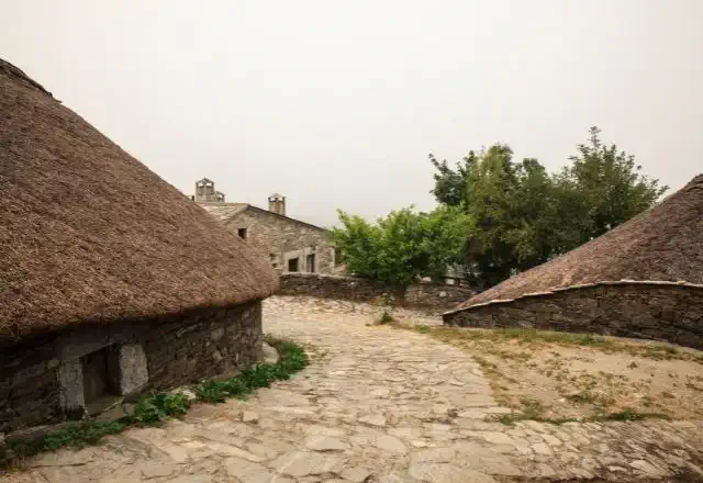
- Pallozas de O Cebreiro - O Cebreiro
- Church of Santa María la Real - O Cebreiro
Typical dishes
- Cheese D.O. O Cebreiro
- Chestnuts
- Galician stew
- Slaughter by-products
- Galician Empanada
- Meat from autochthonous livestock
- day 27
Stage 26. O Cebreiro - Triacastela (20.8 km)
We leave O Cebreiro towards Triacastela, leaving behind the hostel and we follow a dirt path that goes up the Pozo de Area mountain, until we gain 100 metres of height difference and reach 1,332 metres. From the top we can contemplate the spectacular panoramic view: to the north we can see the beautiful Navia valley and the imposing Picos de Ancares, to the south the extraordinary Sierra de O Courel.
We continue along a forest track until we reach Liñares, where we come across the church of San Esteban, a pre-Romanesque church dating back to the 15th century. VIII. From here the path begins to ascend over Os Ancares, taking us through a succession of ups and downs through forests. After reaching the Alto de San Roque (1,270 m) we can admire the bronze statue of a pilgrim fighting against the wind, created by the sculptor José María Acuña as a tribute to all the pilgrims who have overcome these passes.
After this ascent, we continue parallel to the road and reach the village of Hospital da Condesa. We continue our route through a complicated stretch due to the steep slopes until we reach Padornelo, where we find the church of San Xoán (15th century).
We leave the church behind and take strength for the hard ascent of the Alto do Poio which, at 1,337 metres, is the highest peak of the Way of St. James in Galicia. The ascent is hard, but it is compensated by the extraordinary views that give us strength to reach the top. Once we reach the top, we can take a well-deserved rest in the Albergue del Puerto bar.
We continue our stage descending along a dirt track to Fonfría, which preserves the old hospital for pilgrims Santa Catalina and in its parish church there is a 17th century gilded silver chalice.
We continue descending until we reach the villages of O Biduedo and Fillobal and As Pasantes in the municipality of Triacastela. We advance quickly, but not before stopping at an imposing centenary chestnut tree. We arrive at the small village of Triacastela and put an end to our first fully Galician stage.
To consider
If we do the stage in winter, we must be attentive to the weather, as we are in an area of frequent snowfalls that make it impossible for pilgrims to pass through. In case of snow it is recommended to follow the road to avoid getting lost.
Places of interest
- Church of San Estevo de Liñares
- High of San Roque
- Church of San Xoán do Hospital
- Alto do Poio
- Chapel of San Mamede - Triacastela
Typical dishes
- Cheese D.O. O Cebreiro
- Meat from autochthonous livestock
- Slaughter by-products
- Galician stew
- Chestnuts from Os Ancares
- Typical homemade sweets from Os Ancares
- day 28
Stage 27. Triacastela - Sarria (17.9 km)
We leave Triacastela and on our way to Sarria we are presented with two well signposted options: Samos or San Xil? Both options are of great interest, so the decision is yours.
Stage Triacastela - Sarria via San Xil (17.9 km)
After crossing the avenue Camino José Cela we take the detour on the right, which takes us to a local road towards San Xil. After passing A Balsa, along a steep slope we arrive at the Fonte dos Lameiros, with a large shell.
We continue up an asphalted track to San Xil, where we find a vending machine. We continue by road to the vicinity of the top of Riocabo, where we leave the asphalt to enjoy the most beautiful stretch of the stage. Lush forests of chestnut, oak and birch trees escort us down to the small village of Montán.
We continue down to Fontearcuda and cross the road to take a path that avoids the long detour of the road. We cross a river and continue along a path that comes back to the road. The centenary forests give way to green meadows, a landscape that we will see until Furela, where we can regain strength in the bar at the roadside.
We leave behind the village of Furela and enter, at last, the municipality of Sarria. We arrive at Pintín, where there is also a bar and a restaurant. We continue close to the road and we enter a wooded stretch that leads us to the public hostel of Calvor.
After passing Aguiada, Airexe and San Mamede do Camiño we start to see Sarria in the distance. We continue the last stretch through small slides, we pass by a campsite and we arrive at Sarria.
Stage Triacastela - Sarria through Samos (25 km)
At the fork we turn left towards Samos. In this variant we will have to be guided by the arrows, since we will not see cairns. We leave following the road until we reach San Cristovo do Real, where we can see the pazo of Lusío and the Casa Forte. We continue past the village of Renche, walking through a beautiful natural environment on the banks of the river Oribio. We arrive at Lastres and Freituxe, from where we go up to the parish of San Martiño, with a Romanesque church.
At the exit of San Martiño we cross the road through a tunnel and go straight down to Samos, enjoying an impressive panoramic view over the monastery. The spectacular Benedictine monastery of Samos is one of the oldest in Spain. It was founded in the 6th century and has 1500 years of almost uninterrupted monastic life. There are guided tours and you can get your credential stamped.
After the usual visit, we leave Samos by road and arrive at Teiguín, where we cross the road to take a track that goes up by hand. From here the path alternates paths with asphalted tracks and enters the small villages of Gorolfe, Veiga and Sivil. In the latter, we cross the river Sarria over a medieval bridge with a chapel.
We arrive at the concello of Sarria through the village of Perros, where we see a manor house. We cross the road to get to Aguiada, where we connect with the variant by San Xil and we do the last 4 kilometres to Sarria, our end of the stage.
To consider
The stage through San Xil is 6.6 kilometres shorter and crosses one of the most beautiful valleys of the French Way. If we decide to do this stage, it is advisable to leave with enough water and food, as we will not find many services where we can stock up.
On the other hand, the Samos stage is a little longer and goes through spectacular oak and chestnut forests on the banks of the river Oribio. Undoubtedly the most interesting part of the stage is the visit to the Benedictine Monastery of Samos, one of the most impressive monuments in Galicia.
Although it is a difficult decision, whichever path we take, we are sure to get it right.
Places of interest
- Church of San Cristovo do Real - Por Samos
- Benedictine Monastery of Samos - Around Samos
- Church of San Esteban - By San Xil
- Church of San Salvador - Sarria
Typical dishes
- Porco Celta
- Octopus á Feira
- Galician Veal
- Fried Milk
- Roscones
- Filloas of milk or blood
- day 29
Stage 28. Sarria - Portomarín (22 km)
We say goodbye to Sarria, with our minds set on Portomarín, along the rúa Maior and follow the arrows until we reach a viewpoint adorned with a cross, from where we have an excellent panoramic view of the town.
We pass by the Convent of La Magdalena and go down to the river Pequeño to cross the medieval bridge of Aspera. The path takes us through meadows and orchards, we cross the railway tracks and then a small stream over a wooden bridge. We climb up a steep slope to Paredes, where there is a pre-Roman fort.
From Paredes we arrive at Vilei, where we find a fabulous rest area with all kinds of vending machines and a stamp with which we can decorate our credentials. We continue on asphalt to Barbadelo, where we must visit the Romanesque church, paying attention to its façades and capitals.
We leave Barbadelo behind and continue along a path to the villages of Rente and Mercado da Serra, where we find a tavern. We continue straight on along a wooded path that leads us to the fountain of Pelegrín, the mascot of Xacobeo 93. We pass by the Marzán Mill and a little further on we cross the road to go through Leiman and Peruscallo. We leave the asphalt to advance to Cortiñas and Lavandeira.
Between stone walls and forests we reach Brea and Morgade, where we find the much photographed milestone of the 100 kilometres.
The road continues along the asphalted track to Mirallos, where we find the Restaurant O Mirallos, a spectacular place to eat. Next we can see the Romanesque church of Santa María, which was moved stone by stone from Ferreiros. After passing A Pena, we advance to O Couto and Rozas, where it is common to find cattle. We leave the asphalt to take a wooded path in slight ascent. We pass the village of Moimentos and arrive at Mercadoiro, where there is also a bar.
Then we visit Moutrás, and after an obligatory stop at the Peter Punk shop, we gently descend along the basin of the river Miño, interspersed with asphalt and dirt while we can see Portomarín in the background. Without further ado we reach Parrocha, we cross a road to Vilacha.
We now start a steep descent that takes us to the Miño river and the beautiful village of Portomarín, which shines with its white facades and grey roofs. After crossing the long bridge over the reservoir, we go up the steps of the chapel of A Virxe das Neves and enter the centre of the village. We finish the stage and enjoy a pleasant afternoon in one of the most beautiful villages of the French Way in Galicia.
To consider
The stage between Sarria and Portomarín has all the necessary services for the pilgrim. We won't have any problems with refreshments, every few kilometres we will find a great variety of places to rest and have a drink.
There is a belief that says that if we don't climb the Portomarín staircase in one go we will have bad luck for the rest of our Camino. So you know... No stopping!
Places of interest
- Church of Santiago de Barbadelo
- Church of San Xulián de Chorente
- Santa María de Ferreiros
- Church of San Nicolás - Portomarín
Typical dishes
- Eels
- Cake of Santiago (the best of all the Way of St. James)
- Aguardiente (Gastronomic feast)
- Stones of Portomarín
- day 30
Stage 29. Portomarín - Palas de Rei (25 km)
We leave Portomarín in the direction of Palas de Rei from the Church of San Nicolás and descend along the Rúa Compostela to the road, which we must cross to the right to continue along the hard shoulder of the road. We cross the river over a footbridge, turn right and enter a beautiful uphill path.
We cross the road at the height of a factory and pass by a couple of farms before arriving at Toixibó, where we will be struck by a beautiful granary. We continue ascending to Gonzar, where we can make the first stop to regain strength.
From here, the Way continues along a slope that climbs up to Castromaior with a final steep slope (about 600 metres). At this point it is worth taking a detour from the Camino to visit the Castro de Castromairor, a Celtic site that bears witness to the past of the Galician community.
We leave Castromaior looking for the road, which we cross to go along a path for a kilometre and a half until we reach O Hospital do Alto da Cruz. We leave the village crossing a bridge over the road, we turn left onto an asphalted track that leads us to Ventas de Narón, with a very well preserved temple.
We advance ascending until crowning the Ligonde mountain range, enjoying some stupendous panoramic views.
We follow the path that descends to A Previsa and Os Lameiros, where we will find one of the most famous and unique crosses in Galicia, dating from 1679, from here the path turns off the road along a path on the left, following a steep ramp that leads us to Airexe to visit the church of Santiago, with Romanesque remains and sepulchre, a cruceiro and a rectory house.
We continue down the path until we find a washhouse and arrive at the village of Portos, where some huge ants will welcome us. From here, we can leave the path for a moment to visit the Romanesque temple of Vilar de Donas, which houses several sarcophagi of Knights of the Order of Santiago.
We follow the road and arrive at Lestedo, where on the right hand side we see its rectory, now converted into a rural house. The road continues without loss to A Brea and Alto del Rosario. If the day is clear we can see the Sacro peak, a mountain very close to Santiago de Compostela.
Before arriving at Palas de Rei, we will cross the village of Rosario, which owes its name to the prayer of the walkers as thanks for the good luck during the journey. The last stretch of the stage we take a path on the left side of the road, we pass next to the Os Chacotes hostel and we enter Palas de Rei, ending our stage.
To consider
Those pilgrims who wish to visit the monastery of Vila de Donas, should deviate 2.3 km from the Camino. A neighbour has the keys and acts as a guide.
Places of interest
- Church of Santa María de Gonzar
- Castro de Castromaior
- Church of Santa María de Cortapezas - Castromaior
- Monastery of Vilar de Donas
- Double-sided cross - Os Lameiros
- Church of San Tirso - Palas de Rei
Typical dishes
- Rustic bread from wood-fired oven
- Galician octopus
- Lacón with turnip tops
- Arzúa-Ulloa D.O. Cheese
- day 31
Stage 30. Palas de Rei - Arzúa (29 km)
This is the longest stage of the French Route within the Galician community, so we recommend taking it easy and enjoying the surroundings, as it is also one of the most beautiful stretches of the route. A stop in Melide, the capital of Galician octopus, is a must for every pilgrim. After regaining strength, the last few kilometres won’t take much effort. You will also find a small oasis in Ribadiso de Abaixo, where, if the weather is fine, you can take a dip. - day 32
Stage 31. Arzúa - O Pedrouzo (20 km)
This stage is a pleasant walk on flat and comfortable terrain, with plenty of bars and restaurants that will encourage you to take it easy. You will alternate between villages and pine and eucalyptus forests. Small towns like Salceda mark the halfway point of the stage, a perfect stop to recharge your batteries before the last kilometres of the stage. - day 33
Stage 32. O Pedrouzo - Santiago de Compostela (19 km)
At last the last stage of your journey is here. As we said before, the sooner you start walking today the better, because the sooner you will get to Santiago de Compostela. Once you arrive at Monte do Gozo, you will discover that pleasant sensation when you first see the towers of the cathedral. A perfect panoramic view before savouring your last kilometres and making the triumphal entrance to the Plaza del Obradoiro. - day 34
End of the Camino
After arriving... End of the Camino
Frequently Asked Questions
-
Is the French Way of Santiago difficult?
The French Way of Santiago is the most popular and traveled route of the Camino, but its difficulty level can vary depending on the section and the pilgrim's preparation. While the total route covers approximately 768 kilometers from Saint-Jean-Pied-de-Port in France to Santiago de Compostela, it is divided into stages that allow the journey to be adapted to each person's abilities. Here are the main factors that determine its difficulty:- Elevations and terrain: The early stages, particularly the crossing of the Pyrenees from Saint-Jean-Pied-de-Port to Roncesvalles, are among the most challenging, with significant elevation changes and mountainous terrain. However, other sections, such as the Meseta of Castile, are much flatter and more accessible.
- Climate: The weather can greatly impact the difficulty. In summer, the heat in the Meseta can be exhausting, while in spring and autumn, rain and mud can complicate the journey. In winter, some mountainous stages can be tougher due to snow.
- Duration: The duration of the Camino is another factor. Completing the full route can take between 30 and 35 days, requiring good physical stamina. However, many pilgrims choose to walk only the final stages, especially from Sarria, covering the last 100 kilometers in about 5 days.
Based on the pilgrim's experience, we can recommend the following sections:- For experienced pilgrims: They will find a challenge in mountainous stages like the Pyrenees or the ascent to O Cebreiro, but will be rewarded with breathtaking scenery.
- For beginners: While the full Camino may be demanding, it's possible to walk only more accessible sections, such as the last 100 kilometers from Sarria, without facing major difficulties.
-
What are the most important towns on the French Way?
The French Way of Santiago passes through a series of towns and cities rich in history, culture, and unique landscapes. Some of the most important towns and cities along the French Way are:- Saint-Jean-Pied-de-Port (France): The starting point of the French Camino, this picturesque town at the foot of the Pyrenees is known for its cobbled streets and the impressive Santiago Gate.
- Roncesvalles: After crossing the Pyrenees, Roncesvalles marks the entry into Spain. Its collegiate church and historical significance make it a key spiritual stop for pilgrims.
- Pamplona: Famous for its San Fermín running of the bulls, Pamplona is a vibrant city with rich medieval heritage, highlighted by its cathedral and city walls.
- Logroño: The capital of La Rioja, known for its wines and delicious gastronomy. Logroño is an excellent place to enjoy tapas on the famous Laurel Street.
- Burgos: Burgos boasts one of the most impressive Gothic cathedrals in Spain, a UNESCO World Heritage Site. Its historic center is also a must-see on the Camino.
- Carrión de los Condes: This small town in the province of Palencia stands out for its rich medieval history and Romanesque churches, offering a more intimate experience on the Camino.
- León: With a majestic Gothic cathedral, the Convent of San Marcos, and vibrant urban life, León is one of the most important cities along the route, ideal for taking an extended break.
- Astorga: This city features the Episcopal Palace designed by Gaudí and a beautiful cathedral, serving as a crossroads between the French Camino and the Via de la Plata.
- Ponferrada: Famous for its Templar castle, Ponferrada is the gateway to the El Bierzo region and an important stop before tackling the mountains of Galicia.
- O Cebreiro: This charming mountain village is one of the most iconic stops on the Camino, known for its traditional palloza houses and its connection to the Holy Grail.
- Sarria: A starting point for many pilgrims who wish to complete the final 100 kilometers required to earn the Compostela. Sarria is an essential stop.
- Portomarín: This town is notable for its unique history, having been relocated stone by stone after the construction of the Belesar reservoir. Its fortress-like church of San Nicolás and its location by the Miño River make it a special stop before reaching Santiago.
-
How long does it take to do the Camino de Santiago from France?
The French Camino de Santiago is one of the longest routes of the Camino, spanning around 768 km and typically divided into 33 stages. Therefore, with this division, it takes 33 days to complete the Camino de Santiago starting from Saint Jean A-Pied-De Port (France) on foot. Each stage represents the distance you cover in a day, from the starting point of the stage to the endpoint, where you'll spend the night. The stages can vary in distance and difficulty, and it’s important to remember that they can be adjusted according to your pace and physical condition. Some pilgrims choose to break up longer or more challenging stages, while others may extend the shorter, easier ones. It all depends on finding a place to stay. -
Where does the French Way start?
The French Way of the Camino de Santiago begins in Spain at Roncesvalles (Navarra), coming from Saint Jean Pied de Port. However, there is also another starting point after crossing the Somport Pass, in Candanchú (Huesca), known as the French Way through Aragón or the Aragonese Way. This route merges with the French Way from Roncesvalles in Puente la Reina (Navarra). -
What are the most beautiful stages of the French Way?
Some stages of the French Way stand out for their natural beauty, historical richness, and cultural significance. Here is a selection of the most beautiful stages of the French Way:- Saint-Jean-Pied-de-Port - Roncesvalles
- Burgos - Hontanas
- León - Hospital de Órbigo
- Rabanal del Camino - Cruz de Ferro - Ponferrada
- Ponferrada - Villafranca del Bierzo
- O Cebreiro - Triacastela
- Triacastela - Sarria
- Sarria - Portomarín
- Mystical Landscapes: O Cebreiro, a small mountain village, is known for its traditional "palloza" architecture and its almost magical atmosphere, especially when enveloped in mist. From here, the Camino winds through mountains and valleys, offering spectacular views of the Sierra de O Courel.
- Culture and Tradition: O Cebreiro is a place of great historical significance on the Camino. It is home to the Church of Santa María la Real, dating back to the 9th century, known for housing the legendary miracle of the Holy Grail. This village is also the entry point into Galicia, a region rich in Jacobean traditions and culture.
- Variety of Landscapes: As the path descends towards Triacastela, pilgrims transition from mountains to valleys, crossing lush forests, small streams, and charming Galician villages. The diversity of landscapes in a single stage is what makes it so special.
- Spiritual Experience: Many pilgrims describe this stage as one of the most spiritual on the Camino, thanks to its tranquility, natural beauty, and connection with ancient Galician traditions.
-
What are the toughest stages of the French Way?
Throughout all the routes and stages of the Camino de Santiago, there is abundant beauty, nature, and heritage. However, these come amidst dozens of kilometers, with some sections and stages being easier to traverse and others more challenging. The latter are often characterized by significant elevation changes and, at times, long uphill stretches. Below, we’ll inform you about the most talked-about stages and climbs due to their physical demands on the French Way. For many, these are considered some of the toughest stages of the Camino de Santiago.- Saint-Jean-Pied-de-Port – Collado Lepoeder
- Cizur Menor – Alto del Perdón
- Hospital – O Cebreiro
- Boente – Arzúa
-
How many kilometers is the French Way to Santiago?
The total distance of the French Camino is approximately 768 km from Roncesvalles. It's important to note that this distance can vary depending on the complementary or alternative routes a pilgrim might choose along the way. Another possible starting point for the French Camino is from Somport, known as the Aragonese Camino, which adds around 160 additional kilometers. -
Where does the French Way start in France?
The French Way of the Camino de Santiago begins in France at Saint Jean Pied de Port, one stage before Roncesvalles and before entering Spain. It can also start at Somport, another entry point from France that connects with the Aragonese Way, which in turn links up with the French Way at Puente La Reina. Another option is to start from any French city, as they will eventually connect with either Saint Jean Pied de Port or Somport.
French Way from Roncesvalles to Santiago de Compostela
From 1335 €

Reviews
Ramon
manuel gomez llopis
Albert
Estefanía Guasch
Gerardo
Elena Martín Pérez
Raúl González López
Lucía Fernández Romero
Sergio León Cabrera
Isabel Rivas Ortega